thompson peak |
||
| intro
|
the trail started out
following fishhook creek through a pine forest. the first mile was relatively flat
for about a mile until i came to the first junction in the trail. a right turn and i
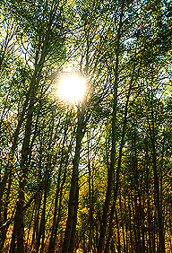
left fishhook creek, across a wide clearing, and switchbacking up a 400' ridge through
beautiful aspen trees. the leaves were just beginning to show their autumn colors,
with leaves glowing in the morning sun.
at the top of the ridge, i came upon the forest service sign-in board, where i stopped to sign in, have a snack, and shed some layers as i began to warm up. just as i began to leave, another man came up behind me to sign in. we exchanged some "good mornings" and i continued on. about a half mile later, i stopped to snap a photo of the mountain i would be climbing the next day as the same guy caught up to me. we discussed our destinations and discovered that we were on our ways to the same place, thompson peak. he introduced himself as tom from boise, and we struck up conversation as we continued hiking together. a little later, i had to stop to take care of some hot spots on my heels that were in danger of erupting into huge blisters. tom continued on while i put some moleskin on my heels and snacked some more. (i also had to catch my breath, but didn't want tom to think i was a wimpy hiker!).
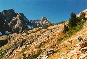
to reach the lake at the base of thompson peak ("no name lake") required stepping off the designated trail and blazing a trail due west along a ridge. i had picked a spot on the map to veer off the trail, and sure enough, when i reached that spot, there was a cairn (stacked rocks to indicate a trail) signifyin a lesser trail leading off to the west. this trail led me through some heavy brush and often disappeared, leaving me to search for where the trail picked up again. a few times, i had to backtrack to find the trail again, but always managed to find it, although i wondered whether this was leading me to a point from which i could reach the lake. about a mile later, i met up with tom again. he was checking his map, trying to pinpoint where he was. we were glad to see each other because either we were on the right track,... or we were both lost. we decided to continue on together. we had to stop several times when the trail would slowly disappear and we'd have to sniff out where it picked up again. making matters worse, all this time we were traversing along the side of a ridge, off-camber (hiking along the slope), so each step bent our ankles down the slope. a couple hundred feet below us, fishhook creek drained down from the lake we were headed towards, but we were unable to follow it directly because of some cliffs that would have blocked our path. so our trail took us around the side and over these cliffs, depositing us on a ledge just below the lake. at this point, the trees thinned out as we made our way up a drainage to no-name lake (9,000'). the eastern edge of the lake was stacked with boulders the size of VW bugs. we stopped to snack and discuss our plan for the day. i made my way over the boulders down to the lake edge to filter some water for us. when i returned, tom and i decided to stash our packs and attempt williams peak (10,635') today as a warm-up for thompson peak tomorrow... |