williams peak |
||
| intro
|
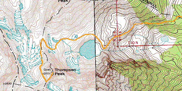
we stashed our
packs amidst some boulders and maneuvered through the boulder field that bordered no-name
lake. once on soft-ground, the scout for campsites was on. it seemed almost
impossible to find a bare spot large enough to put a tent on, let alone two tents.
we came upon a one-man tent set up on green grass, crowded between large rocks--it seemed
like the only possible campsite! we continued on up, constantly eyeing the terrain
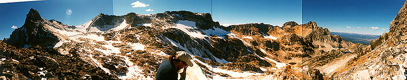
for clear spots. a short ways up when crossing a small snow-field, we met a man coming down the mountain. we asked him about the tent, and sure enough, it was his and he was leaving that afternoon. so we made tentative plans to use that spot for one of our tents. continuing on, we reached another smaller lake at the edge of a large snow-field. for some reason though (i forget why now), we circled uphill around the snow-field, across some very loose scree (small, loose, sharp rocks somewhere between the size of.... oreo cookies and... cornish game hens -- like the visuals???). the footing was hairy for a while. with each step, we would slide down a couple feet, dislodging the scree. we decided this was hopeless and made our way back down to the snow-field. we were now at a point between thompson peak (to our left) and williams peak (to our right). beyond the snow-field lay another 1/4 mile of small boulders which occasionally shifted and creaked under our weight. each step required steady concentration to test our footing and the steadiness of the rocks. after this series of boulders, we were confronted with a 100' high wall that ran directly between thompson and williams. our only options were to go to the extreme ends of this wall and climb up over them. after a little surveying, we decided to stick to the williams side and made our way up a steep scree slope alongside the wall. about half-way up, though, the wall presented us with some steps that we were able to scramble up. here, we used handholds extensively. we reached the top of the wall and swung around the edge of the ridge, giving us this spectacular view of goat lake (to the extreme right) and the couloir leading up to thompson peak (to the extreme left). |
| we stopped to rest and take
in the immense panorama before us. below, we could see 3 small specks making their
way down from thompson to goat lake. after a snack and a discussion of our game
plan, we continued straight up the southwest ridge of williams (which we had just climbed
up to). a problem arose. williams peak is not a single peak, but a series of parallel spines or rock outcroppings that just happened to be running perpendicular to our direction of travel. simply put, this meant that we would have to climb over each spine and back down the other side in order to reach the true summit of williams. we got to a point where these spines were just steep enough to allow us to climb up, but would have been impossible to get back down without rope. so we aborted our mission at about 10,000' and headed back. instead of backtracking, we opted to cut straight down a scree slope, bypassing the 100' wall. i figured out after sliding most of the way that the best way to maneuver scree is to adopt a sort of "scree tango"--dancing down the slope as the rocks slide out beneath. |